Atlas# 12 Area of Town: Northside
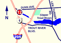
6800 Dunn Ave. (Map It)
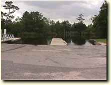
The Dinsmore ramp is a well utilized ramp for smaller boats less than 20 feet providing direct access to upper portions of the Trout River for recreational users as well as some commercial fisherman. The ramp is in fair condition, however the right side of the ramp has silted in and lacks sufficient depth and stability for launching larger boats. There have been reports of some submerged logs in the basin area, so boaters should exercise care.
Click here to link to the NOAA website for weather conditions and tide reports.
|
  |
DRIVING DIRECTIONS:
From I-295:
1. Take the US-1 N/US-23 N exit, exit number 11B,
towards CALLAHAN.
2. Ramp is on southeast side of bridge crossing Trout Creek. |
 |
| PROVIDES ACCESS TO: |
NUMBER OF TRAILER PARKING SPACES: |
| Upper Trout River |
20 |
| OVERFLOW PARKING: |
DOCKING AND STAGING: |
| Some available off site |
fixed and floating docks |
| ADA ACCESSIBLE: |
HOURS OF OPERATION: |
| Yes |
5 a.m. - 10 p.m. |
| NUMBER OF RAMP LANES: |
AMENITIES: |
| 2 |
Play ground, fishing area along bank |
| COORDINATES: |
|
| N 30° 26.237' W 81°45.688' |
|
| SPECIAL CONDITIONS: |
VESSEL USE RATING: |
| Navigation Notice: submerged logs in the basin area, so boaters should exercise care. |
B= vessels less than 22 Feet |
| VESSEL USE RATING GUIDE |
A= unlimited;
B= vessels less than 22 Feet |
C = jon boats and jet skis;
D= hand launch only |
|