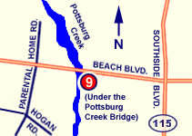
DRIVING DIRECTIONS:
From Downtown:
1. Head EAST on BEACH BLVD
2. Ramp is on Southeast side of Pottsburg
Creek / Beach Boulevard Bridge. |
 |
| PROVIDES ACCESS TO: |
NUMBER OF TRAILER PARKING SPACES: |
| Pottsburg Creek |
12 |
| OVERFLOW PARKING: |
DOCKING AND STAGING: |
| Some available for fee |
Floating dock
|
| ADA ACCESSIBLE: |
HOURS OF OPERATION: |
| No |
24 hours/7 days |
| NUMBER OF RAMP LANES: |
AMENITIES: |
| 1 |
Port-o-let, fishing area |
| COORDINATES: |
|
| N 30° 19.123' W 81° 39.711' |
|
| SPECIAL CONDITIONS: |
VESSEL USE RATING: |
| Strong current, some shoaling near ramp; high vessel traffic. |
B = vessels less than 22 feet |
| VESSEL USE RATING GUIDE |
A= unlimited;
B= vessels less than 22 Feet |
C = jon boats and jet skis;
D= hand launch only |
|