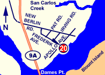
DRIVING DIRECTIONS:
From 9A / Heckscher Drive Intersection:
1. From HECKSCHER DR Westbound, Turn LEFT onto
NEW BERLIN RD.
2. Turn RIGHT onto APOLLO AVE.
3. Turn LEFT onto FREDRICK ST.
4. Ramp is at intersection of Fredrick Street. |
 |
| PROVIDES ACCESS TO: |
NUMBER OF TRAILER PARKING SPACES: |
| St. Johns River |
Room for 2 trailers |
| OVERFLOW PARKING: |
DOCKING AND STAGING: |
| Only along the residential roads |
No docks or fixed structures |
| ADA ACCESSIBLE: |
HOURS OF OPERATION: |
| No |
Sunrise to 9pm |
| NUMBER OF RAMP LANES: |
AMENITIES: |
| 1 |
None |
| COORDINATES: |
|
| N 30° 23.810' W 81° 33.214' |
|
| SPECIAL CONDITIONS: |
VESSEL USE RATING: |
| Unimproved ramp, very limited parking |
C = jon boats and jet skis |
| VESSEL USE RATING GUIDE |
A= unlimited;
B= vessels less than 22 Feet |
C = jon boats and jet skis;
D= hand launch only |
|