City of Jacksonville Update on Potential Tropical Cyclone 9
September 24, 2024
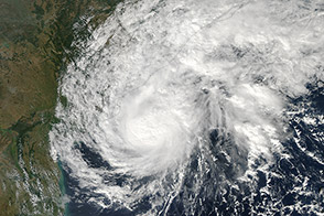
A tropical system is currently organizing in the Western Caribbean Sea and will enter the Gulf of Mexico as a hurricane on Wednesday, September 25. The storm is currently forecasted to make landfall as a major hurricane, potentially on the Big Bend of Florida on Thursday.
The current local forecast for Duval County has the potential for 3-6” of rain, low-end tropical storm force sustained winds (39-57 mph) with gusts of high-end tropical storm force winds (60-70mph), possible hurricane force wind gusts in riverfront and oceanfront areas, 1-3 foot storm surge in isolated areas along the St. Johns River near downtown Jacksonville, and an increased risk for tornadoes. Rain bands are expected to start impacting the area on Wednesday evening with tropical storm force winds beginning by early Thursday morning.
Mayor Deegan has requested that the Jacksonville City Council convene in a Special Meeting for a storm briefing on Tuesday, September 24, at 3:00 p.m. in the Council Chamber, 117 West Duval Street, 1st Floor, City Hall-St. James Building. At the conclusion of the Special Council Meeting, the City Council will adjourn and immediately convene its regular meeting
The City of Jacksonville Emergency Preparedness Division continues to closely monitor Potential Tropical Cyclone 9. Our partners stand ready to mobilize and respond as the tropical system approaches. More updates will be provided to the public tomorrow.
Citizens should remain prepared and take the guidance of officials seriously. All final storm preparations should be made before Wednesday afternoon:
Assess Your Home, Property, and Plan: Walk around your property, clean up any limbs or debris that may clog storm drainage systems, and secure loose outdoor items that could become projectiles. This helps prevent damage to your property and neighboring properties. Be mindful of trees that could become uprooted from heavy winds and the already saturated ground from the previous weeks of rain. Ensure your supply kits are stocked and that you have an emergency plan for your family.
Clean Drains and Gutters: Ensure that all drains and gutters are clear of debris so that water can drain properly. Blocked gutters can lead to water overflow, which might cause water damage to your home. Cleaning them out now can help mitigate potential flooding issues if we receive heavy rainfall.
Avoid Driving Through Flooded Roads: If you encounter flooded roads, do not attempt to drive through them. The depth of water is not always obvious. It only takes a small amount of water to float a vehicle, which can lead to dangerous situations. Always heed barricades and road closure signs put in place for your safety.
Stay Weather Aware: Keep up-to-date with the latest weather forecasts and updates from official sources such as the National Weather Service and the Emergency Preparedness Division (JaxReady.com). Being informed will help you make timely and safe decisions for you and your family. JEA encourages customers to visit JEA.com/storm to ensure your contact information is up to date and to register for power restoration alerts.